Inishturk, island of the wild boar
GPS Coordinates at the Pier: 53.7047 -10.0902
By Daria Blackwell
About Inishturk
Inishturk (Inis Toirc in Irish), Wild Boar Island, has been
inhabited on and off since 4,000 BC. In its present phase, it has had permanent
residents since at least 1700. Whereas its population before the Famine was
close to 1000, it has a permanent population of only about 70 residents today.
There are two main settlements, both on the eastern end of the island –
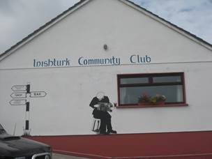
Ballyheer and Garranty. The Community Club called the Mountain Common sits on
the hill between the two villages. It is the centre of all social life on the
island.
Since the famine in the mid-1800s, Islanders have been
emigrating to America and England to find work and fortune, although now people
are returning to spend their retirement years in its embrace. So whereas Irish
was the first language at the beginning of the 20th century and although
Gaeilge is still widely spoken, the island is now primarily English speaking.
Situated between Inishbofin and Caher Island about 14.5 km
(9 miles) off the coast, Inishturk is a small (5 x 2.5 km) and beautiful
island. Geologically, Inishturk was formed by two separate folds of schist and shale
that rise out of the Atlantic as a continuation of the same folds that formed
Croagh Patrick on the shores of Clew Bay in County Mayo. It rises boldly from
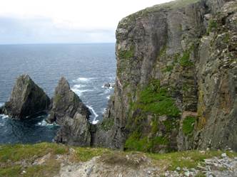
the wild North Atlantic as cliffs to the northwest and steep hills to the north.
The southern shore slopes gently down to the sea, where rocky outcroppings
punctuate pristine white sand beaches.
Life on the islands can be quite challenging through the
winter months. In the summer, their populations tend to swell with tourists
clamouring to experience island life. Culturally, Inishturk offers a rare
glimpse into island life not yet spoiled by tourism and hopefully to remain so
for the foreseeable future. Life is real here.
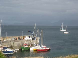
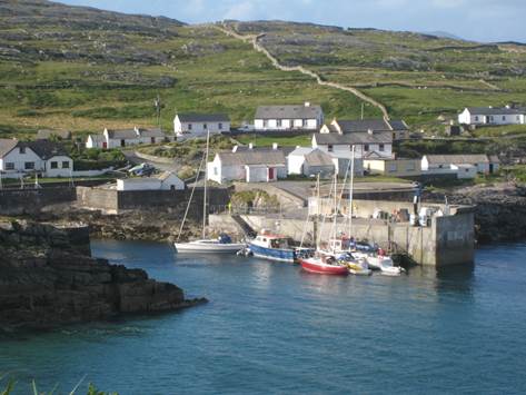
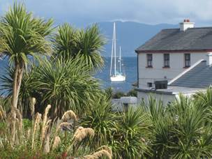
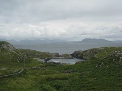
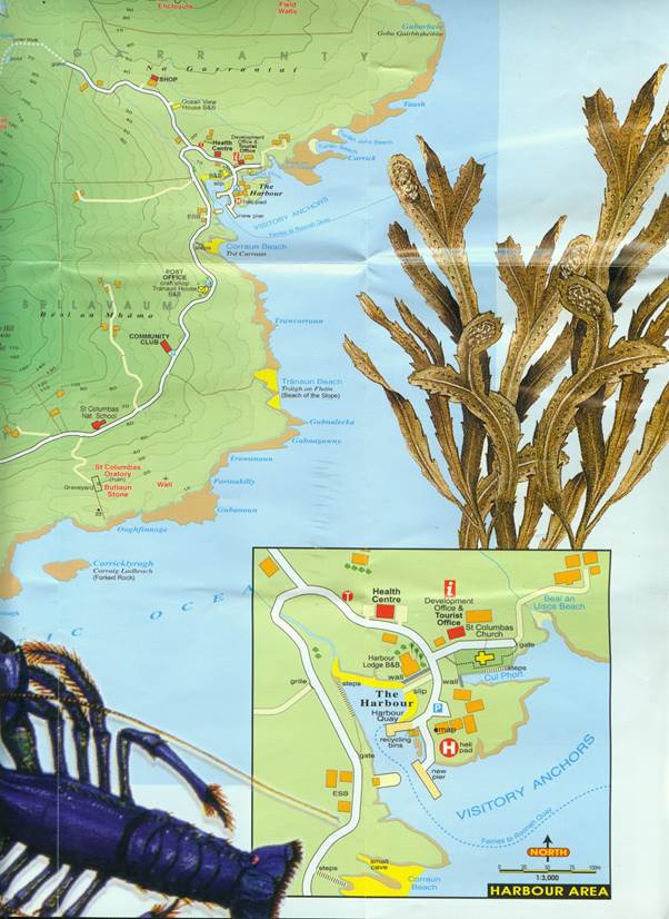
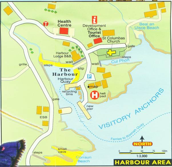
Moorings and dockage
Inishturk has a lovely harbour with a new pier and several
secure visitor moorings, which tend to be a bit exposed. If coming by boat, there
are four visitor moorings. Visitor moorings are free of charge and maintained
by Mayo County Council. Yachting
Monthly included Inishturk among the handful of locations in the “UK” with
favourite visitor moorings.
There is often room to tie up alongside the fishing boats on
the pier. It is critical to ask permission as the fishermen may be heading out
during the night. Do not obstruct the ferry approach, which makes the trip
twice a day.
See also http://www.inyourfootsteps.com/sailing/harbours/280/inishturk
Getting there
If you don’t have your own boat, you can still visit
Inishturk via ferry. In the summer (01/05-09/30), O’Malley
Ferries have twice daily sailings from Roonagh Pier near Louisburg on most
days.
Amenities
There are few services for visitors, so self-sufficiency is
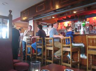
key. The only real gathering place on the island is the Community Club. There
is a small shop with very basic provisions and a library with internet access.
Showers and toilets are available, as is a lovely bar with stunning panoramic
views. The walk up to the Centre can be a bit strenuous up the hill and around
the harbour. Chances are there will be someone at the pier to offer you a lift
if you so choose. The islanders are very welcoming.
Things to do
 Walking is perhaps the major activity and breathtakingly
stimulating. The natural scenery is among the finest and the island has many
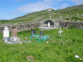
interesting archaeological sites. The old church up on the hill was in use in
the penal times dating back to the sixteenth century. The cemetery was a pagan
centre before it was used as a graveyard as the 1838 map shows a stone circle
indicating its pagan origins. The little oratory is in the shape of a coffin
and holds a holed stone for healing and marriage rituals. Apparently, the
oratory originally had a corbeled roof.
Walking is perhaps the major activity and breathtakingly
stimulating. The natural scenery is among the finest and the island has many
interesting archaeological sites. The old church up on the hill was in use in
the penal times dating back to the sixteenth century. The cemetery was a pagan
centre before it was used as a graveyard as the 1838 map shows a stone circle
indicating its pagan origins. The little oratory is in the shape of a coffin
and holds a holed stone for healing and marriage rituals. Apparently, the
oratory originally had a corbeled roof.
Walk up the hill from the harbour past the church and new
medical centre through Garranty and continue out past civilization onto the
commonage. Open a gate and walk onto land that appears untouched by humans with
the exception of a lightly travelled road across the moors. Climb the gentle
slope until you come to an opening between two hills with a lake appearing to
the left. A number of Beehive house sites situated around the lake area date to
circa 1500 BC. A beautiful valley between two rises and lovely lakes
makes for an idyllic and sheltered if not isolated spot to take a break.
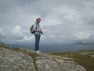
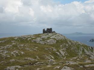
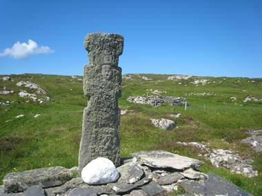
Set out across the hills, walking on the soft heather. At
the top stand the ruins of the old signal tower 722 ft above sea level. The Martello
tower was built 1805-1806 as one of 82 towers erected by the British along the
west coast finishing on Malin Head. Inishturk was number 57. The men in the
watch towers intended to discourage Napoleon by using a heliograph or steel
plate polished to reflect the rays of the sun to passing ships. Here you will be rewarded with breath-taking 360 degree
views across to Mayo on one side, the islands off the coast in the other
direction, and the hills of Connemara in the third direction. At the crest, the
winds blow insistently even on a calm day.
The best activities for visitors involve taking advantage of
the natural environment of flora and fauna on shore and in the sea. Ornithology enthusiasts
will be thrilled by the number of bird sanctuaries on the island cliffs. The
flora of Inishturk is of international importance, harbouring rare endangered
species such as the Spotted Rock-Rose.
Set off across the valley and make your way across wet lands
via a rudimentary bridge built by the farmers of the commonage. Skirting the
next set of peaks you come across a beautiful rock precipice straight down to
the sea. The cliffs form a crescent shaped inlet. They are alive with birds
protecting their nests and feeding their young. The island is a breeding ground
for Fulmars, Guillemots, Black Guillemots, Razorbills and the charming Puffins.
The best time to view breeding seabirds is from May to July. The locals claim this
is the place to be for the best views of sunsets in Europe!
Heading back toward the main harbour, you come to the beautiful snippet of a harbour at Portdoon, which seems carved out of the rock with an
impossibly treacherous slit between the rock walls as an entrance, hence
the name (Port An Dun). There is ample
archaeological evidence of early settlers around this harbour, the only
natural lagoon on the island. Many recent
settlers have congregated at the southwest corner in the village of
Ballyheer.
Tradition suggests that the harbour was used by the Norse
men way back in time. The pirates harboured their galleys in the lagoon below,
screened by the rocks from the observation of those sailing past. They were reputed
to be the last Danes in Ireland who knew how to make bier lochlannach, a priceless drink made from heather.
Legend has it that the fort was surprised and taken by the Irish, who
slaughtered everyone except for one old Dane and his son, offering to spare the
captives if they told the secret of the bier or, as others have retold, the
hiding place of their vast treasures collected as plunder over many years.
The old pirate, fearing the
boy might be tempted or tortured into betrayal, offered to tell if his son was
put to death first so none of his kin might see his treachery. This done, the
pirate captain tore away from his captors and jumped over the cliff into the
deep chasm shouting insults and carrying his secret to Odin.
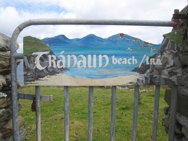
On the eastern side of Inishturk are the secluded Tranaun
and Curran beaches, with fantastic clear blue waters, ideal picnic and swimming
spots after a hike. Scuba diving in the Caribbean blue, crystal clear waters
is a joy as the waters abound with lobster and large crabs as well as fish of
many varieties.
For the full island experience, round the day off with a
pint of Guinness in the island's lively Community Centre. Most weekends you’ll
find live traditional music and dancing till the wee hours.
Events
Mid-June Annual traditional music festival
Well known for its traditional music and set dancing
sessions, Inishturk’s annual trad festival is not to be missed. Visitors are
very welcome.
Regatta in July
A festive event held annually consists of live music on the
pier to accompany currach races. Islanders from surrounding islands
participate and there are land-based events on shore as well. The day
culminates in a live music celebration at the Community Club.
Annual Sports Day in August at the football pitch carved
out of the rock
Every year, a variety of sporting events are held (bag race,
egg & spoon race, shoot outs, etc) which culminate with a now historic
islands football match. Inishturk was the winner of the 2008 All Ireland
Islands Championship. The football pitch is one of the most amazing as it is
carved out of the solid rock.
 Annual Pilgrimage to Caher Island 15 August
Caher Island is a mystical uninhabited island close to
Inishturk. It is only possible to land there in calm weather as there is no
sheltered harbour. The island has the ruins of an early Christian monastery
and the remains of a chapel adorned with 7th century carved crosses.
The Island also seems to have contained the hermitage sites of seventh century
monks, perhaps followers of St Columba. It is accessed by boat from Inishturk.
Accommodations
There are three B&Bs on the island. There are no
restaurants other than the B&Bs.
The Community Centre serves meals on some weekends and
offers a campground as well as showers and toilet facilities.
More reading
Ireland: Taking a boat to Inishturk
Tempted by a romantic place that supposedly doesn't welcome
visitors, Jim Perrin takes a boat to Inishturk and its even more rarely visited
sister island, Caher http://www.telegraph.co.uk/travel/722929/Ireland-Taking-a-boat-to-Inishturk.html
Inishturk Island Loop Walk
http://www.mayowalks.ie/WalkingTrails/LocalisedLoopWalks/InishturkIsland/
Download a brochure with the loop walks
Inishturk Island Facebook Page
https://www.facebook.com/pages/Inishturk-Island/219487621453251
1944 Tourist Association Survey
http://www.mayolibrary.ie/en/LocalStudies/IrishTouristAssociationSurvey/ClareIsland/Inishturk/
Heritage Tour of Inishturk with Poet Ger Reidy
http://www.podcasts.ie/2010/03/mayos-heritage-week-6/
Irish TV Episode about Inishturk Island
http://www.irishtv.ie/ep-97-inishturk-island/
Movie of Inishturk Island by Westport GP, Ollie Whyte
http://www.youtube.com/watch?v=BLVvj5AKDNg
Blog by Fairwinds
http://www.bluemoment.com/ireland/20.html
click to enlarge
The Old Church
The Present Graveyard
The Signal Tower
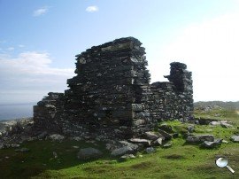
Remains of signal tower number 57 atop Inishturk affording 360 degree views of
the surroundings.
For more information on Inishturk, go to:
http://www.inishturkisland.com/