
|
|
||
|
|
|
|
Meridional Parts CalculatorBelow is a form using JavaScript that calculates the meridional parts from a given latitude: Mercator projection and Meridional PartsThe first Mercator chart (the ordinary maps and charts used nowadays) was published by the Flemish cartographer, Gerardus Mercator in 1569. However, the mathematical methodology of Mercator projection was not published until 1599 by an Englishman Edward Wright, who published a table of Meridional Parts. With this table, the Mercator sailing was developed and it provides a mathematical solution of the plot as made on a Mercator chart by using difference in meridional parts and longitude differences. What are Meridional Parts?
In the Mercator projection, a different way is being used to represent the Earth spheroid. All the meridians are plotted as parallel lines on the chart making it necessary to increase the distance that represents a degree of latitude (which is actually a constant on the Earth spheroid) so as to maintain the aspect. This new distance unit is named as meridional part which is the increased length of the meridian on a Mercator chart measured from the equator to the parallel (latitude) and is expressed in minutes of the longitude scale. As meridional parts are of the same distance units of the longitude difference, the plain triangle that represents the course and distance between two points on a Mercator chart could then be solved by applying simple trigonometry theories. This method of calculating course and distance or vice versa is called Mercator sailing.
|
|
|
|
Europe: Port Aleria, Rosnakilly, Kilmeena, Westport, Co. Mayo, Ireland - USA: PO Box 726, Mahwah, NJ 07430 All content on this site is subject to Copyright© - All rights reserved. Contact us - Advertising - Privacy - Terms & Conditions - Copyright & Trademark - Webmaster |
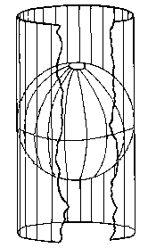 On the Earth spheroid the distance of a degree of longitude is about the same as a degree of latitude at the equator which equals 60 nautical miles. The distance for a degree of longitude decreases as it gets closer to the pole where all the meridians meet at a single point while the distance for a degree of latitude remains almost unchanged.