|
|
||
|
|
|
Tools and more info
Misc |
Thinking About Heading South? Part One: Navigating the ICW.by Mark and Diana Doyle
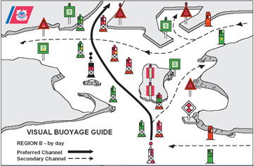
The Waterway was a rough ride in 1912 when Henry Plummer took his catboat along the Eastern Seaboard’s inland route, told in his story The Boy, Me, and the Cat: Life Aboard a Small Boat from Massachusetts to Florida and Back in 1912. Back then, notched boards nailed to posts marked the channels. If the top corner of the board was cut off, the deeper water was closer to the post (whatever “closer” meant). If the bottom corner was cut off, deep water was “farther off.” The channel marking was rough—and the dredging was worse—so Plummer’s three-foot draft catboat was constantly touching bottom. Today the Waterway is maintained by a fleet of dredges and is well marked with dayboards, buoys, and range markers. Piloting the ICW is now straightforward if you work with the navigation system that has evolved over the years. It doesn’t mean you won’t touch bottom, but you can enjoy a much more relaxing trip than Plummer’s back in 1912. The ICW runs parallel to the Atlantic and Gulf coasts from Manasquan Inlet, New Jersey to the Mexican border. AIDS TO NAVIGATION (ATONs)There are two important facts to remember about aids along the Intracoastal Waterway: they run clockwise around the coast and they are uniquely marked. Because the ICW runs along the shore, the conventional adage of “red, right, returning from seaward” becomes unclear. So the Coast Guard adopted the following clockwise convention: moving in a southerly direction along the Atlantic Coast, then in a northerly, then westerly direction along the Gulf Coast, is considered returning from seaward. You can remember this rule as “red, right, returning to Texas.” Occasionally, given the ICW's frequent crossing and joining of established waterways, you often experience a sudden change in lateral buoyage. For example, colored aids to navigation “swap sides” three times near the Savannah River intersection.
To prevent confusion, the aids of the Intracoastal Waterway are uniquely marked. Every dayboard or buoy—in addition to its regular numbering, shape, and color characteristics—shows a yellow reflective symbol. When traveling southbound, a yellow reflective square indicates a port-side mark. A yellow reflective triangle indicates a starboard-side mark.
Caution: Expect to see yellow squares on triangular (red) dayboards and yellow triangles on square (green) dayboards. This is common as the ICW meanders and intersects channels with buoyage having opposite cardinal significance! So when following the ICW in a leg from New Jersey to Texas, keep yellow triangles [ Always verify each upcoming aid’s yellow square or triangle, and flashing light sequence, especially around inlets and river junctions. The simple habit of verifying each Waterway mark (which becomes second nature after a few days) saves a lot of grief. If you take a wrong turn, you may still be in deep water because you’ve wandered into a non-ICW channel. You now need to re-locate the ICW channel, which will likely put you on the wrong side of an aid, in shallow water. DayboardsDayboards are the most common navigational aid along the Waterway. Look for dayboards in three forms: mounted on a single piling, on a dolphin (a collection of strapped, teepee-like pilings), or on a larger piling structure. The type of mounting has no navigational significance. The dayboards are conventional, with triangular red dayboards marked with even numbers, and square green dayboards marked with odd numbers. The numbers are large and very visible, unless the sun is low on the horizon and the board is silhouetted.
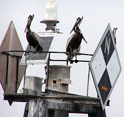
In addition, some aids are lit. A good rule of thumb is: if an aid is lit, it’s lit for a reason. Lighted aids are much more expensive to build and maintain. Heed lit aids and think about why they are lit. Along the Intracoastal Waterway, a lit aid calls attention to an important junction, turn, or hazard. In addition, the light's characteristics (color and rhythm) have significance. A colored light has lateral significance. For example, a flashing green light of a certain pattern calls your attention to keeping the aid on the appropriate side of your vessel. A quick flashing light typically identifies a turn requiring an abrupt, rather than a gradual, course change. Drop AidsBecause of the shifting and shoaling nature of the Waterway, the Coast Guard often places small temporary drop aids, or floaters, to supplement larger permanent aids. These aids are typically small nuns or cans designated with an additional letter. For example, a red drop aid between R2 and R4 would be labeled R2 "A". As with all Intracoastal Waterway aids, drop aids also show the ICW yellow square or triangle. Since drop aids are placed in areas of shoaling they should be given a wide berth. Mile Markers
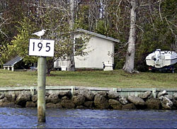
The statute mile convention is firmly entrenched, with stm markers shown on NOAA charts every five miles. Along much of the Waterway, the statute miles are marked with ICW mile marker boards. These small signs, when available, are white with black lettering. They may be attached to a dayboard, piling, tree, or even painted on a rock! Ranges
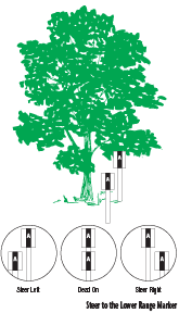
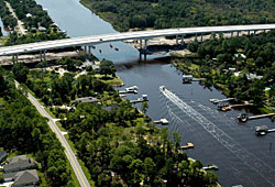
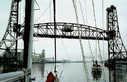
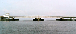
The important task is to stay on a front range by looking ahead and keeping the forward (lower) and rear (higher) range markers directly in line. With a back range, this involves occasionally glancing back over your stern. Keeping the range markers aligned will assure you stay mid-channel. To correct your course, follow this simple rule: steer to the lower range marker. Don’t become so fixated on the range you continue past its intended departure. The channel typically ends and turns before the range aids are reached or out of sight. Be on the lookout for the buoy or dayboard marking the end of the range line. Every season several boaters, pleased with their precision range running, forget to depart the line before they’ve hit shallow water. BRIDGESThe official overhead clearance along the Intracoastal Waterway is 65 feet above mean high water. However, the Julia Tuttle Bridge in Miami (stm 1087.2), with a fixed clearance of 56 feet, is an exception. Southbound vessels taller than 56 feet must exit the Waterway by Port Everglades and re-enter no closer than Government Cut, Miami. In addition, some of the 65-foot bridges have been reported short, so vessels with heights over 62 feet should use caution or watch the tides. For example, the Wilkerson Bridge in North Carolina (stm 125.9) has a reported fixed clearance of 64 feet. As boating and land traffic increases, the old low-clearance opening bridges continue to be removed, replaced by fixed 65-foot spans. But there are still more than eighty opening bridges between Hampton Roads and Biscayne Bay. Nearly two-thirds of these are in Florida.
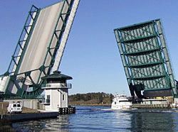
Bridge RestrictionsRestricted openings are times a bridge does not open on request. For example, during restricted hours, a bridge may open on the hour and half-hour only. Holidays refer to federal holidays, in which case the usual rush-hour restrictions do not apply. Restricted hours may also refer to a block of time when the bridge does not open for recreational traffic, such as during the morning and evening rush hours. If you accidentally arrive at a bridge during its restricted hours, the bridge will not open for you as a pleasure craft. Caution: Bridge schedules change! For example, Broward County recently completed a three-month trial of simplified openings. Temporary and permanent bridge restrictions are published in the Local Notice to Mariners.
Even during restricted hours, bridges open for commercial traffic. During a blackout period, you may be able to “sneak through” with a commercial vessel. Clear this with the bridge tender before proceeding. If it is not during restricted hours, begin by hailing the bridge on the VHF, using that state’s bridge channel (VHF 13 or 09). Only call the bridge tender if you are unable to hail them by VHF. Caution: A bridge will typically not open unless you officially request an opening. Circling in front of the bridge is not considered a bridge opening request and, if you are a lone vessel, will often result in you missing the opening. Remember, it is equally important to state a non-intention. As a courtesy, if you are approaching a bridge and do not intend to pass through, hail the bridge tender and advise him. For example, many boaters stop at Alligator River Marina for inexpensive diesel or an overnight stay. This marina is approached southbound by coming right up to the Alligator River Swing Bridge, turning hard to starboard, and following the bridge into the basin. You will have a very agitated bridge tender if you approach the bridge for three miles at flank speed without making radio contact! Bridge tenders have other duties, so they may not respond to you immediately. Wait a reasonable amount of time before hailing again. Additionally, re-naming bridges seems to have become a modern-day government sporting activity. We have endeavored to list all bridge name alternatives that may be in favor this season. If one doesn't work, try another. According to Coast Guard regulations (technically not part of the Inland Rules), you may also hail a drawbridge by sounding one prolonged blast, followed within three seconds by one short blast, “repeated until acknowledged by the bridge tender.” Unfortunately, this strategy usually backfires. No one likes being honked at and you’ll usually end up waiting until another boat requests an opening. Forget the horn. The inland rules of the road dictate who has the right of way in passing situations. Vessels with a following current have right-of-way over vessels motoring up current. If you are heading against the current, stand off until the other vessels clear the bridge opening. With the possibility of a strong current setting them onto the bridge, the boat with the current needs your courtesy and room to pass through safely. Rather than assume a “first-come, first-served” lineup for the bridge opening, hail your fellow cruisers and suggest queueing up in order of hull speed. This will make everyone's life easier, avoiding the post-opening jockeying, passing, and rock-and-roll. You don't need to purchase one of the Doyles' guides to receive their updates, discounts, and announcements. Important information such as revised bridge schedules, changes to marine facility services, shoaling, and closures is sent via email, Twitter, and Facebook (www.facebook.com/on.the.water.chartguide). Sign up at: www.onthewaterchartguides.com.
(for a better viewing experience, you may wish to turn off your ad blocker)
|
|
||||||||||||||||||||||||
|
Europe: Port Aleria, Rosnakilly, Kilmeena, Westport, Co. Mayo, Ireland - USA: PO Box 726, Mahwah, NJ 07430 All content on this site is subject to Copyright© - All rights reserved. Contact us - Advertising - Privacy - Terms & Conditions - Copyright & Trademark - Webmaster |