|
|
||
|
|
|
There and back again Tools and more info The Importance of Practicing MOB Drills and Crew Training Misc Top 10 Online Boating Resources |
Computers for NavigationNavigation displays for the rest of usby Alex Blackwell
GPS and chart plotters were not even a glint in someone’s eye back then. Yes, there was the occasional sputnik sighting, and the first computers had been built. I learned machine code that semester and actually wrote a program for a calculator that could add and subtract. Now everything has gone way beyond what even the writers of the early Star Trek episodes could possibly have imagined. We have computers everywhere and in everything. Have you ever been to a really tricked out yacht and lusted over the large displays in the cockpit? Yes, this is surely something I for one have lusted over for years. Particularly now that my eyesight is not quite what it once was and a bigger screen is really becoming a necessity, I have been pouring over the literature collected at the boat shows and visiting retail websites. But, “wow”, “ohmygoodness” and “ouch” are about the only expressions that come to mind when I see the sticker price for one of these 11-13 inch beauties. A few years ago we discovered and subsequently publicized in magazines such as Cruising World the free raster and vector charts available from NOAA (http://chartmaker.noaa.gov). Ever since then we have been using these charts on a PC together with a $20 GPS mouse as our primary electronic navigation resource. Yes, we still always have and always will have paper charts out in the cockpit as we've been subject to loss of power on two occasions. But the S57 ENC vector charts have proven to be indispensable for planning and the RNC raster charts (scanned from paper charts) we find preferable for approaches or more detailed viewing. Unfortunately, as yet neither library is complete, but hopefully NOAA will receive the necessary funding to resume adding charts. We also like to correlate what's on the screen with visual reference marks as well as paper charts because there are occasions when one of the three does not corroborate the other two. Safety is our main concern.
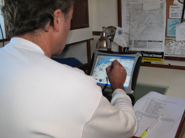
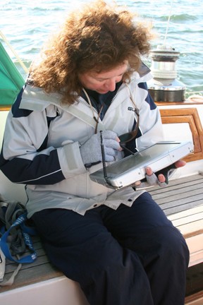
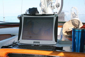
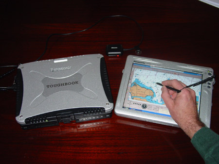
One of our biggest challenges initially was keeping our precious laptop PC dry while having it out in the cockpit. Secondary to that but not by far was difficulty viewing the screen in daylight. We came up with ingenious combinations like a framing a hood over the laptop and covering our head and the whole shebang with a towel to block out the sun – not a pretty sight. If the plan was to use the laptop as a stand-alone navigation device, as we have now done for several years, then a waterproof, daylight viewable PC would have to be the tool of choice. We searched far and wide for a low cost daylight viewable monitor we could plug in and watch all day and night. This was a quandary until a friend showed us a tablet PC he was using for racing. This we had to check out. As it turned out, this led us to two realistic and totally viable options that are alternatives to dedicated displays. Panasonic’s Toughbook CF-19 is one such beast. Though it is priced comparably with dedicated displays at around $3,500, it is a very nice and powerful computer built to military specifications and has a touch screen to boot. The screen can swivel and fold down converting the computer into a tablet PC. Add the very reasonably priced Fugawi Marine ENC charting software (~ $200), a $20 GPS mouse, and the free NOAA charts to the Toughbook and you have complete system in your cockpit. The bottom line is that you would not need the expensive navigation system if all you are looking for is the GPS charting. We just did a 500+ mile cruise using this configuration and were very happy with the results. We used the vector charts for planning and routing over greater distances as they do load more slowly, and then switched to the raster charts for greater detail. We kept the computer under the dodger where it was viewable and yet out of the way. We also moved it to the helm position if the helms-person wanted it for tight navigation.
Using the ‘Remote Desktop’ feature built into Microsoft Windows XP Pro and wi-fi, the tablet can take over the functionality of the PC and become a remote display. Leaving the PC safe and dry at the navigation station or in another location, you can take the tablet anywhere you please. All the software and functionality your PC has is thus literally at your finger tips. Call up a chart, plot a course, view your radar display, play iTunes, you name it. One interesting aspect of the Panasonic Toughbook that we found is that it has yet to be targeted at the marine industry. To find out more about these products or to learn where you might purchase them go to Panasonic.com and type Toughbook in the search field. You can also buy a reconditioned one at almost half price at toughbookexchange.com.
|
|
|||||
|
Europe: Port Aleria, Rosnakilly, Kilmeena, Westport, Co. Mayo, Ireland - USA: PO Box 726, Mahwah, NJ 07430 All content on this site is subject to Copyright© - All rights reserved. Contact us - Advertising - Privacy - Terms & Conditions - Copyright & Trademark - Webmaster |