|
|
||
|
|
|
|
Coastal Navigation Using GPS for Sail and Powerby Frank J. LarkinI find this to be the kind of book that every mariner who completes the USCG Auxiliary Basic Boating and Safety course should acquire to progress to the next level of competence in navigation. It covers all the tools, techniques, and principles you need to know to get yourself and your boat from point A to B, and back again, safely and expeditiously. It covers the basics of reading charts, where to find all the rest of the information you need in references publications and almanacs, the system of aids to navigation, how to use nautical instruments, how to convert from paper coordinates to GPS readings, dead reckoning, and tides and currents. Using the GPS is covered from considerations in choosing a system to which buttons to press on the typical screens of chartplotters you might buy.
It's written in simple easy-to-understand language with visually enhancing illustrations, tables, and tools throughout. It is in a workbook format with questions and answers for you to test your comprehension with each chapter. Perhaps most valuable are the appendices that walk you through how to check the accuracy of your compass, how to create deviation tables, and how to calculate a speed curve for your vessel - the latter being particularly useful as an optimization tool given today's gasoline prices. Appendix seven also has a collection of useful navigation forms that you can photocopy for use aboard. The title is however a 'little' misleading. I expected to jump right into turning on that shiny new 12 inch GPS-enabled chartplotter interfaced with radar and sonar. After all, the pictures on the cover show a handheld GPS and a dedicated chartplotter. I imagined to be following the instructions on how to match electronic datum to paper charts, setting a course with waypoints, constructing routes and double checking against paper charts, even creating a deviation card for the ship's magnetic compass using GPS directional readings. I hoped for a chapter on the virtues of different charting software, finally providing a comparison of all the different systems. I anticipated a chapter on sources of electronic charts and the virtues of raster vs vector formats. Much of this is covered in Chapter 12, although not in as much depth as I would have expected. I thought this book would be mainly about GPS applications with reference to traditional methods, whereas its focus is traditional methods with reference to GPS applications. I came at it with a bias that GPS navigation is equivalent with electronics, whereas the author equates it with coordinates. In fact, in the Introduction, the author cautions you not to jump ahead because you need to learn all the basics first.
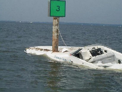
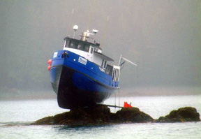
So getting back to this review with a new mindset, the most important aspect is that so many boaters we have met are adamant about not needing all this learning. They think that paper charts are passe, that dead reckoning is for dead pirates, and that all they need is a chartplotter to safely pass from one point to another. Unfortunately, we've heard too many stories and have seen evidence of too many occurrences of navigational misfortune that truly deserved the Darwin award. The picture of the boat on the rocks is one. Larkin's book will help you avoid a scenario like this, the bottom line of which is costly salvage operations. If you go into this book with the understanding that it is about navigation as well as GPS, rather than specifically about electronic navigation, you will most certainly not be disapointed - it is excellent. Perhaps it is time for another edition taking it to the next level of navigation evolution, and truely focusing on GPS navigation with paper charts as a backup.
|
|
||||
|
Europe: Port Aleria, Rosnakilly, Kilmeena, Westport, Co. Mayo, Ireland - USA: PO Box 726, Mahwah, NJ 07430 All content on this site is subject to Copyright© - All rights reserved. Contact us - Advertising - Privacy - Terms & Conditions - Copyright & Trademark - Webmaster |