Coastal Art Maps Introduces Gorgeous Maps of the Sea Islands of South
Carolina’s Coastline
Limited Edition Art Maps Showcase South Carolina’s Beauty,
History & Diversity
Coastal
Art Maps, a company that captures the beauty of the East Coast shoreline
through breathtaking, hand-drawn maps, has just released its “Sea Islands of
South Carolina” map series, the latest additions to their stunning collection.
These three new maps depict the beaches, towns and historic landmarks that span
much of the 130 miles of the South Carolina coastline.
Joseph
S. Tarella, the talented map-maker at Coastal Art Maps, was able to expertly
spotlight the iconic historic towns, coastal attractions, islands and waterways
along the South Carolina shore.
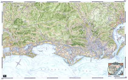
The
first of the exquisite, hand-drawn maps in the new collection, Daufuskie Island
to Fripp Island, depicts the areas from the Georgia border, including Hilton
Head, Port Royal, St. Helena, Fripp, and Hunting Islands and the town of
Beaufort. This lovely map includes Hilton Head, the boot-shaped sea
island nestled along the South Carolina coast, with its Atlantic Ocean beaches,
pristine golf courses, and quaint Harbour Town Lighthouse. Additionally,
this map showcases Port Royal’s harbor and military bases, and the bucolic town
of Beaufort, which boasts history, heritage and the natural beauty of the
coastal Lowcountry.
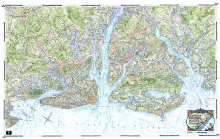
The
second map, Edisto Island to Isle of Palms, highlights areas including
Charleston as well as Kiawah, Johns, James, and Seabrook Islands.
Charleston’s historic beauty is featured, with such notable locations as Battery Promenade, Waterfront Park, Charleston
Harbor, and Fort Sumter, where the first shots of the Civil War rang out.
Kiawah, a barrier island, is depicted as an oasis of untouched natural beauty,
with miles of pristine beaches, perfectly preserved maritime forests, sand
dunes, and marshes.
Finally,
the third map, Capers Island to Cat Island, highlights Bulls, Murphy and Cape
Islands. This map portrays the stunning,
tranquil settings steeped in history along the shore: classic
plantations, white sandy beaches, rolling dunes, beautiful parks such as
Francis Marion National Forest, and gorgeous marinas. It also
majestically captures the untamed wilderness of Bulls Island, with its Wildlife
Refuge and areas of uninhabited beauty.
“It’s
been a true pleasure capturing the beauty of the South Carolina shoreline, rich
with history and resplendent against the backdrop of the extensive Lowcountry
landscape. My ‘Sea Islands of South Carolina’ collection showcases
more than 100 miles of breathtaking South Carolina coastline, from historic
cities like Charleston and Beaufort, to the wild, untamed islands of
uninhabited beauty,” explained artist Joseph S. Tarella, Owner of Coastal Art
Maps. “South Carolina’s shoreline is picturesque and wonderfully diverse,
and my new maps celebrate its beautiful beaches, idyllic harbor towns,
sparkling marinas, as well as selective and sensitive development throughout
these East Coast islands."
Tarella
has captured the beauty of the East Coast shoreline – from Cape Cod,
Massachusetts to Key West, Florida - through his hand-drawn and painted
artwork. Each map represents a moment when an ever-changing world is briefly
frozen in time. Tarella uses the time-honored tools of pen-and-ink and
watercolor washes, resulting in an extraordinarily tactile quality not easily
achieved using more modern, mechanical methods.
"I've
captured the unique beauty of the South Carolina coast, where people spend
peaceful days enjoying beaches, boating, fishing, hiking, traveling by ferry,
and spending time in the quaint little towns along the shore," Tarella
continued. "These maps will make treasured keepsakes for beach or
boating enthusiasts, nature and nautical lovers, sportsmen, fisherman, art
collectors, and anyone who has spent precious time in these beloved
locales. The maps - singularly or as a collection - make special,
memorable gifts for the holidays, and to commemorate birthdays, weddings,
anniversaries, graduations and other special occasions. They enhance the
décor of any home, office, boat or beach house."
Tarella
started Coastal Art Maps as a hobby. He liked maps and traveling, and when he
built a house on Long Beach Island, he couldn’t find any maps of the area that
he liked, so he created his own. Friends and family loved his colorful
hand-drawn maps and wanted their own versions. Tarella's labor-of-love company
evolved from there.
Artist Joseph Tarella offers a series of limited-edition
art maps of selected coastlines, including the New Jersey
shoreline that was damaged during Hurricane Sandy.
Each map presents an elegant, detailed and accurate rendering of selections of
East Coast land areas, highlighting their juxtaposition and relationships
between land and water, islands, parks, roadways, and other significant
elements. These comprehensive and beautiful ink-and-watercolor compositions,
offered on full size giclee canvas or half-size watercolor paper, make truly
unique and satisfying acquisitions.
Tarella
combines his architectural experience, passion for travel and love of
map-making to create stunning maps of East Coast beaches. Coastal Art Maps
currently has over three dozen different maps in circulation, depicting areas
including the New York, New Jersey, Massachusetts, Maryland, Delaware,
Virginia, South Carolina, and Florida coastlines. Tarella, a trained
architect and owner of SawickiTarella Architecture+Design PC, also customizes
maps, identifying specific locations, per customer request. For more
information, please visit www.coastalartmaps.com.
