|
|
||
|
|
|
|
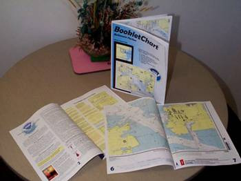
The BookletChartTM
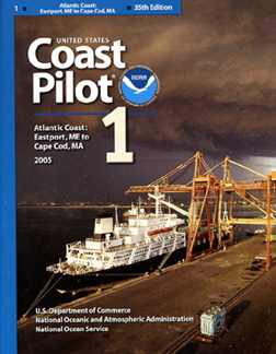
The charts are downloadable as Adobe Acrobat files and they are rather large so you'll need broadband. Printing them can be time consuming without a high speed duplex printer and they will use up a fair bit of ink at the "normal" resolution of about 600 dpi. NOAA has had reports of the individual files taking from 4 minutes to 4 hours to print. You can staple multiple pages together to form a booklet or keep the pages loose in a file. We tried printing and stapling them into a booklet and the pages did not line up perfectly, but it wasn’t bad. While full scale charts are still recommended, these are great for boaters who might otherwise do without and certainly great to supplement older printed charts with newer information. The BookletCharts are on the NOAA site at: http://www.nauticalcharts.noaa.gov/staff/BookletChart.html. If that’s not enough here’s more free stuff from NOAAThe complete US Coast Pilots available free as zipped downloadable filesThe complete US Coast Pilots are available free as zipped downloadable files. If you are not familiar with Coast Pilots, they are essentially text versions of nautical charts. So rather than drawing a picture of the coast, they tell you what you will find there in words…and some pictures.
They have not been updated by subsequent corrections published in the NIMA Weekly Notice to Mariners, the Coast Guard district's Local Notice to Mariners, or NOAA's website. These files do NOT meet 33 CFR 164 carriage requirements unless these corrections have been incorporated. Persons copying or reproducing the provisional ECPs do so at their own risk and liability. Get them here: http://nauticalcharts.noaa.gov/nsd/cpdownload.htm Okay, one more!NOAA has been busy this summer. And contrary to some reports, they are not going out of the charting business. Far from it. NOAA may be leaving behind the large format paper chart business eventually, but that does not mean they are going to leave us in the dark. For example, PocketChartsTM are a new inexpensive (ie, not free) introductory product that has a miniature image of a NOAA chart on one side and safety information on the other side. Although “not intended for navigation” these charts are a great resource for kayakers, canoeists, and fishermen to keep in their back pockets for reference. We applaud NOAA for their innovation in trying to keep us all safer while we venture out on the waters.
|
|
|||
|
Europe: Port Aleria, Rosnakilly, Kilmeena, Westport, Co. Mayo, Ireland - USA: PO Box 726, Mahwah, NJ 07430 All content on this site is subject to Copyright© - All rights reserved. Contact us - Advertising - Privacy - Terms & Conditions - Copyright & Trademark - Webmaster |