|
|
||
|
|
|
|
HAVFRUE Cable Route Survey
The survey within Irish territorial waters is scheduled to begin on the 14th March 2018 and last for approximately 7 days.
The vessel will be running hull mounted multibeam echo sounder lines along the proposed route with average survey speed of 7.5 kts.
Towing equipment as magnetometer and side scan sonar will be used during the shallow water phase, from 1500m of water depth and shallower. From time to time the vessel will slow down or stop to measure the speed of sound in the water, as well as perform geotechnical measurements necessary for this kind of operation.
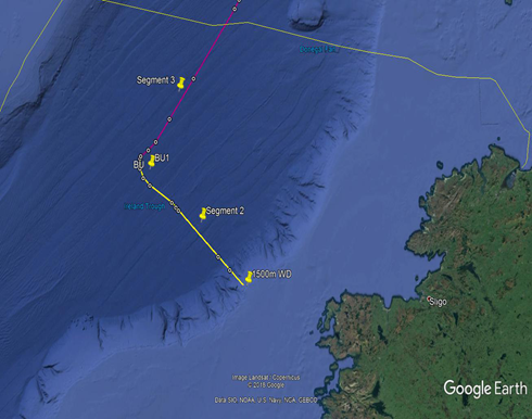
On 14th March 2018 ‘MV Fugro Discovery’ (Callsign: 3EKE6) will start survey operations on Segment 2 within Irish EEZ waters towards the 1500m contour line at the shelf, followed by survey operations at the BU1 position and Segment 3 (see Figure 1).
Survey Area:
Figure 1
Survey operations will be conducted on a 24 hour basis. Throughout the survey operations the vessel will be displaying the shapes and lights prescribed in the International Rules for the Prevention of Collisions at Sea (COLREGS) Rule 27, to indicate that the survey vessel is restricted in its ability to manoeuvre.
A listening watch will be maintained on VHF Channel 16, and the vessel will actively transmit an AIS signal.
All mariners are reminded of their responsibilities under the International Collision Regulations and are reminded of Marine Notice No. 17 of 2007, which gives general advice in relation to the activities of vessels engaged in survey work for hydrographic, seismic, fishing research and underwater operations.
The International Regulations for Prevention of Collisions at Sea (COLREGS) are implemented in Irish law by the Merchant Shipping (Collision Regulations) (Ships and Water Craft on the Water) Order 2012 [S.I. No. 507 of 2012], and the Signals of Distress (Ships) Rules 2012 [S.I. No.170 of 2012]. See Marine Notice No. 06 of 2013. These Statutory Instruments may be purchased by mail order from Government Publications, Office of Public Works, 52 St. Stephen’s Green, Dublin 2. Tel: (01) 6476834/1890-213434. They are also available online at: www.irishstatutebook.ie.
Marine Notices are issued purely for maritime safety and navigation reasons and should not be construed as conferring rights or granting permissions.
Irish Maritime Administration, Department of Transport, Tourism and Sport, Leeson Lane, Dublin 2, D02TR60, Ireland. |
|
|||||||||
|
Europe: Port Aleria, Rosnakilly, Kilmeena, Westport, Co. Mayo, Ireland - USA: PO Box 726, Mahwah, NJ 07430 All content on this site is subject to Copyright© - All rights reserved. Contact us - Advertising - Privacy - Terms & Conditions - Copyright & Trademark - Webmaster |